


ACCESS/MAP
Nagoya Castle to Miya no Watashi/Full Area Map
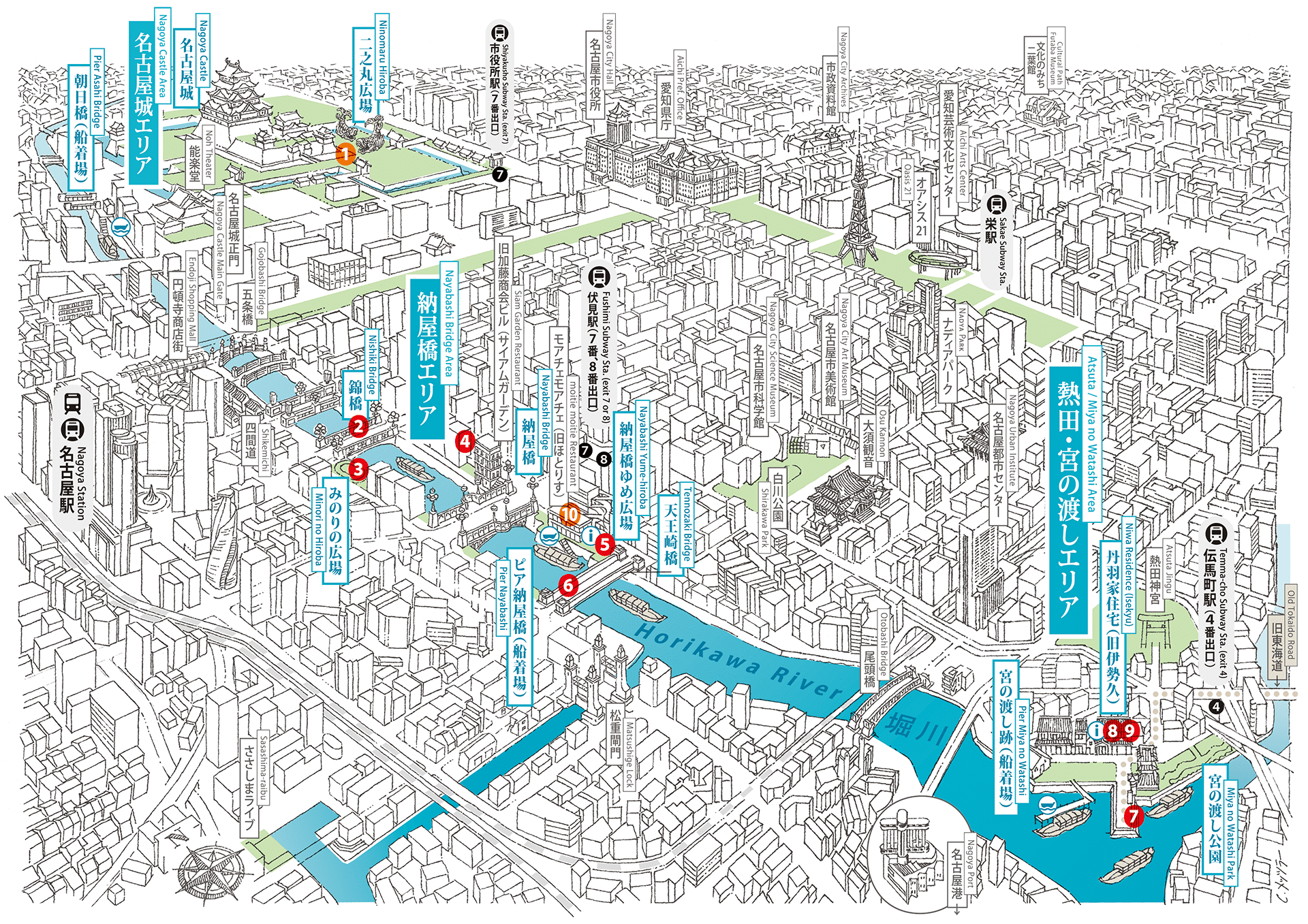
Illustration: Clemens Metzler

[PERFORMANCE] Hiei Kazumasa + Takeichi Manabu / [SYMPOSIUM] Igarashi Taro × Ichihara Etsuko


[EXHIBITION] Sawa Hiraki
[MARCHE] Nayabashi Yoichi

[EXHIBITION] Sato Miyo (Music: BONZIE)

[INFORMATION] MOBIUM

[EXHIBITION] Ito Yuichi

[MARCHE] Miya-no-Hama Ichi (Atsuta Miyashukukai)

[EXHIBITION] Hirakawa Youki

[EXHIBITION] Barrack (Kondo Kanako, Furuhata Taiki) + Ano Daici

[ARTIST TALK] Sawa Hiraki x Akiba Fuminori / [TALK] Looking at Nagoya from Horikawa River: Streaming Future from the Past
Boat Operation
On days that events are held, a boat will operate in two sections of the Horikawa River: from Pier Asahi Bridge to Pier Nayabashi, and from Pier Nayabashi to Pier Miya no Watashi.
Nagoya Castle Area
The development of Nagoya’s culture and economy since the early modern period has focused primarily on the districts around Nagoya Castle. In front of Nagoya Castle (on the south side), the foundations of what is now Nagoya were laid with the establishment of the district called “Kibanwari” where the townspeople lived. Supporting that castle town was the Horikawa River, as it was the core for water transport of the people’s daily necessities. At the time excavation began, the northern end of the Horikawa River was at the end of the canal at Asahi Bridge, and it is said that up to that point, Nagoya Castle’s moat was supplied spring water.
Access (nearest station)
 Shiyakusho (City Hall) Subway Sta. (exit 7), or
 Pier Asahi Bridge
-
PERFORMANCE [MAP No.
 ]
]Hiei Kazumasa + Takeichi Manabu
Video + Sound Performance
“Re: No.3”
- Date/Time:
- Saturday (holiday), March 20th, 18:30-19:00
- Venues:
- Nagoya Castle Ninomaru Square
- Capacity:
- 50 persons
-
SYMPOSIUM [MAP No.
]Collaborative Project: KIN-SHACHI EXHIBITIONIgarashi Taro × Ichihara Etsuko“Streaming History”
- Date/Time:
- Saturday (holiday), March 20th, 19:00-20:30
- Venues:
- Nagoya Castle Ninomaru Square
- Capacity:
- 50 persons
Nayabashi Bridge Area
Seven bridges built during the Edo period cross the Horikawa River, which connects Nagoya Castle to the sea at Atsuta. Named after a site nearby, Nayabashi Bridge was built when the Horikawa River was excavated, in conjunction with the construction of Nagoya Castle. During the Edo period, pottery from Seto, one of the leading pottery producing areas in Japan, was transported via the Yada and Shonai Rivers and collected and inspected at the Owari clan’s storehouses along the side of the Horikawa River (currently near Tennozaki Bridge, Mitsukura Street) before being shipped throughout Japan.
Access (nearest station)
- Fushimi Subway Sta. (exit 7 or 8), or
- Pier Nayabashi
-
EXHIBITION [MAP No.
]Sawa Hiraki
Video Installation
- Venues:
- Nishiki Bridge, Minori no Hiroba Wall
-
EXHIBITION [MAP No.
]Sato Miyo (Music: BONZIE)
Animation + Music
- Venues:
- Nayabashi Bridge Area Wall
-
INFORMATION [MAP No.
]MOBIUM
Media Lab
- Venues:
- Nayabashi Yume Square
-
EXHIBITION [MAP No.
]Ito Yuichi
Media Art + Performance
- Venues:
- Tennozaki Bridge
-
EVENT
GROUND LEVEL (Tanaka Motoko, Onishi Masaki)
Communication Design / Town Planning
- Dates:
- Saturday, March 13th, Sunday, March 14th, Saturday (holiday), March 20th, Sunday, March 21st
- Venues:
- Nayabashi Yume Square
-
TALK [MAP No.
]“Looking at Nagoya from Horikawa River: Streaming Future from the Past”
- Date/Time:
- Monday, March 15th, 18:00-19:30
- Venues:
- moitie moitie
- Guests:
- Takenaka Katsuyuki, Hideshima Eizo, Clemens Metzler
- Moderator:
- Kawamura Yosuke (Co-director of the exhibition)
- Capacity:
- 30 persons
-
ARTIST TALK [MAP No.
]Sawa Hiraki × Akiba Fuminori
- Date/Time:
- Friday, March 26th, 19:00-20:00
- Venues:
- moitie moitie
- Capacity:
- 30 persons
-
MARCHE [MAP No.
〉Cooperative ProjectsNayabashi Yoichi (Nayabashi Night Market)
- Date/Time:
- Friday, March 12th, Friday, March 26th 16:00-20:00
- Venues:
- Promenade between Nishiki Bridge and Nayabashi Bridge
Atsuta/Miya no Watashi Area
Today, the area around Atsuta is surrounded by national roads and buildings, and it is now far from the sea, but around the beginning of the Edo period, it prospered as a base for shipping, with the Ise Bay spreading out before Miya no Watashi, the only maritime route along the Old Tokaido Road. In 1625, a nightlight was erected, indicating the gateway for entering and exiting vessels. Since the Edo period, the development of reclaimed marshlands has proceeded gradually, and the sea has become more distant from this land. Now, these reclaimed mashes have been transformed into land for factories and residential areas.
Access (nearest station)
- Temma-cho Subway Sta. (exit 4), or
- Pier Miya no Watashi
-
EXHIBITION [MAP No.
]Hirakawa Youki
Video Installation
- Venues:
- Miya no Watashi Park, Niwa Historic Residence (formerly Isekkyu)
-
EXHIBITION [MAP No.
]Barrack (Kondo Kanako, Furuhata Taiki) + Ano Daici
Food + Art
- Venues:
- Niwa Historic Residence (formerly Isekkyu, an inn)
Café-Bar Hours:
Fridays, Saturdays, and Sundays from March 12th to 28th 12:00-20:00 (Last order 19:30) -
MARCHE [MAP No.
]Cooperative ProjectsMiya-no-Hama Market Special Edition (Atsuta Miya-shuku kai)
- Date/Time:
- Sunday, March 21st 11:00-15:00
- Venues:
- Miya no Watashi Park